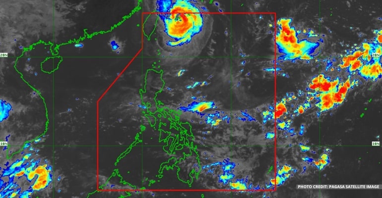
WEATHER UPDATE — According to the Philippine Atmospheric, Geophysical, and Astronomical Services Administration (Pagasa), Typhoon “INDAY” (international name MUIFA) may leave PAR (Philippine Area of Responsibility) tonight or tomorrow if its movement does not change.
The typhoon is now located 415 km Northeast of Itbayat, Batanes (23.8°N, 124.2°E) with maximum sustained winds of 155 km per hour near the center and gustiness of up to 190 km per hour. It is moving North Northwestward at 10 km/h.
“Kapag hindi magbabago ang galaw ng bagyong Inday, inaasahan po natin na lalabas ng PAR ang bayong Inday ngayong gabi o bukas na araw,” PAGASA forecaster Aldczar Aurelio added.
(If the movement of typhoon Inday does not change, we expect that typhoon Inday will come out of PAR tonight or tomorrow.)
Pagasa also said the low-pressure area (LPA) spotted outside the PAR, located 1,995 km East Northeast of Extreme Northern Luzon (24.9°N, 140.8°E), is not expected to enter the PAR. It will move generally Northwestward toward Japan.
For today’s weather forecast, Metro Manila and the rest of the country will have partly cloudy to cloudy skies with isolated rain showers or thunderstorms, with the possibility of flash floods or landslides during severe thunderstorms.
Winds will be strong in Extreme Northern Luzon, moving west, while coastal waters will be rough; moderate to strong in the rest of Northern Luzon, moving southwest to west, while coastal waters will be moderate to rough; and light to moderate in the rest of the country, moving southwest to west and coastal waters will be slight to moderate.
Watch the 5 AM weather update today below:
– WhatALife!/Zed
Source: (PAGASA)
Also read: PAGASA: Tropical Storm “INDAY” may become Severe Tropical Storm


Leave a Reply