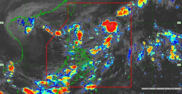
WEATHER UPDATE — According to the Philippine Atmospheric, Geophysical, and Astronomical Services Administration (Pagasa), at 2 AM, the LPA (Low-pressure area) being monitored east of Luzon has become a Tropical Depression and given the local name of OBET.
Tropical Depression OBET is now located 1,055 km East of Extreme Northern Luzon (20.6°N, 132.0°E) with maximum sustained winds of 45 km per hour near the center and gustiness of up to 55 km per hour. It is moving North Northwestward at 10 km per hour.
“Ito ang pangatlong bagyo sa buwan nang Oktubre at panglabing-limang bagyo sa taong 2022,” said PAGASA Weather Forecaster Daniel James Villamil.
(It is the third storm in the month of October and the fifteenth storm in the year 2022.)
At the moment, Bagyong OBET has no direct effect on the country.
The Tropical Depression is forecast to move Northwest or North-northwest until this afternoon, then Southwest or South-southwest until tomorrow. By Friday and Saturday, it will head towards Northern Luzon or the Luzon Strait.
Bagyong OBET may traverse Extreme Northern Luzon or the northern portion of mainland Northern Luzon between Friday evening and Saturday morning. It is forecast to gradually intensify by mid-Friday and may reach the Tropical Storm category by late Friday or early Saturday.
In addition, further intensification is likely once OBET reaches the West Philippine Sea.
Due to the TD, Babuyan Islands, Ilocos Norte, Apayao, and the northern portion of mainland Cagayan may expect moderate to heavy with, at times, intense rains from Friday evening to Saturday morning.
Meanwhile, Batanes, the northern portion of Ilocos Sur, Abra, Kalinga, and the rest of mainland Cagayan may experience light to moderate with, at times, heavy rains.
From Saturday morning to afternoon, Batanes, Babuyan Islands, Apayo, Ilocos Norte, and the northern portions of Abra and Ilocos Sur may expect light to moderate with, at times, heavy rains.
Tropical Cyclone Wind Signal may be hoisted for some areas in Northern Luzon tonight or tomorrow (at the earliest). The highest possible wind signal due to the passage of OBET is Wind Signal No. 2.
For Tropical Cyclone Wind Signal Updates, follow DOST-PAGASA on Facebook or Twitter.
The Shear Line continues to affect the northern portion of Northern Luzon. It will bring cloudy skies and scattered rain showers to affected areas throughout the day.
In the next 24 hours, the prevailing northeasterly surface wind flow will bring strong to gale-force winds over Batanes, Babuyan Islands, and the northern portions of mainland Cagayan, Apayao, and Ilocos Norte.
On the other hand, the southwesterly surface wind flow brings cloudy skies and scattered rain showers to parts of Visayas, especially Eastern Visayas.
WEATHER UPDATE TODAY – October 19, 2022
For today’s weather forecast, areas in Extreme Northern Luzon, including Batanes, Babuyan Islands, Cagayan, and Ilocos Norte, will experience cloudy skies and scattered rain showers due to the prevailing northeasterly surface wind flow.
The rest of Luzon will have fair weather conditions, except for rain showers in the afternoon and evening due to localized thunderstorms.
Eastern Visayas may expect cloudy skies and isolated rain showers due to the southwesterly surface wind flow. The rest of Visayas and the whole of Mindanao are forecast to have fair weather conditions with chances of isolated rain showers and localized thunderstorms.
Watch the 5 AM weather update today below:
– WhatALife!
Source: (PAGASA)
Also read: PAGASA: Typhoon NESAT (formerly NENENG) out of PAR, LPA in Pacific Sea


Leave a Reply