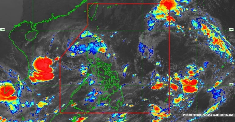
WEATHER UPDATE — According to the Philippine Atmospheric, Geophysical and Astronomical Services Administration (PAGASA), Bagyong Maymay has weakened into a Low-Pressure Area (LPA) at 2 am on Thursday, October 13, 2022. Meanwhile, the Tropical Depression outside the Philippine Area of Responsibility (PAR) may arrive on Thursday morning or afternoon.
At 3 am today, the Low-Pressure Area (formerly known as Bagyong Maymay) is spotted in the vicinity of Casiguran, Aurora.
Weather specialist Benison Estareja reported that Bagyong Maymay made landfall not as a Tropical Depression but as an LPA. As a result, all Tropical Cyclone Wind Signal has been lifted.
It is expected to either cross over the southern parts of Northern Luzon and emerge to the West Philippine sea or disperse and create another weather circulation near the Ilocos Region.
The LPA and shear line continues to bring rain over Aurora and Nothern Luzon. Rain is expected in the morning and will weaken in the afternoon.
Better weather conditions are expected as the LPA, formerly Bagyong Maymay, weakens.
Another LPA spotted 535 km west of Coron Palawan has a possibility of becoming a Tropical Depression within the next 48 hours. However, PAGASA forecasts it will have left PAR within the same period.
Tropical Depression to be named Bagyong Neneng
The weather agency continues to monitor the Tropical Depression outside PAR. At 3 am today, it is located 1,765 km East of Nothern Luzon with a max wind/gust of 45/55 km per hour. It is moving west north-west at 15 km per hour.
To be named Bagyong Neneng, the TD is forecast to enter PAR on Thursday morning or afternoon. It will be the 14th typhoon to enter PAR in 2022 and the second in October.
“Kung saka-sakali po ay papangalanan natin itong bagyo na si Neneng o ang pang labing-apat na bagyo ngayong 2022, pangawala naman ngayong October,” said PAGASA Weather Specialist Benison Estareja.
The TD will move westward towards extreme Northern Luzon and may intensify into a tropical storm on Friday, but further intensification is not ruled out.
Heavy rainfall is possible over Northern Luzon beginning Saturday.
Tropical Cyclone Wind Signal No. 2 may be hoisted over areas in extreme Northern Luzon, including Batanes and the Babuyan Islands. Meanwhile, parts of Northern Luzon will be under Signal No. 1 over the weekend.
For Tropical Cyclone Wind Signal Updates, follow DOST-PAGASA on Facebook or Twitter.
Weather Today – October 13, 2022
For today’s weather forecast, Northern Luzon may expect moderate to, at times, heavy rains, which may result in floods and landslides. Heavy rainfall advisories are also expected in the morning.
Southern and Central Luzon, including Metro Manila, may expect cloudy skies and high chances of rain. Isolated rain showers and thunderstorms may occur in the afternoon.
Meanwhile, the LPA and shear line has no direct effect on Visayas and Mindanao.
Western Visayas, Zamboanga Peninsula, and the Sulu Archipelago have high chances of rain in the morning.
In the afternoon, most of Visayas, the Caraga Region, and Northern Mindanao may experience rain. On the other hand, Davao Region and Soccsksargen may expect rain in the evening.
Watch the 5 am PAGASA Weather Update here:
– WhatALife!
Also read: PAGASA: Bagyong Maymay may become an LPA before landfall


Leave a Reply