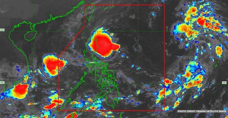
WEATHER UPDATE — According to the Philippine Atmospheric, Geophysical and Astronomical Services Administration (PAGASA), Tropical Depression or Bagyong Maymay is forecast to weaken into a Low-Pressure Area (LPA) before landfall. Meanwhile, the Tropical Depression spotted outside the Philippine Area of Responsibility (PAR) may arrive on Thursday evening or Friday morning and may intensify into a Tropical Storm.
As of 3 am today, October 12, 2022, Bagyong Maymay is spotted 305 km east of Baler, Aurora, with a max wind/gust of 45/55 km per hour. It is moving southwest slowly.
PAGASA’s Track and Intensity Forecast showed the Tropical Depression will slowly westward toward Central Luzon or remain stationary in the next 12 hours. Bagyong Maymay is also slowly weakening and may become a Low-Pressure Area (LPA) before making landfall at Aurora.
Another LPA is spotted inside PAR, located 520 km west of San Jose, Occidental Mindoro. While it is already leaving PAR, it still has a possibility of becoming a Tropical Depression.
The TD spotted 1920 km east of Southern Luzon may enter PAR on Thursday evening or Friday morning. It will generally move westward towards Extreme Northern Luzon.
The TD, to be named locally as Bagyong Neneng, may intensify into a Tropical Storm category by Thursday. It will bring heavy rains to parts of Northern Luzon.
Tropical Cyclone Wind Signal Updates (as of 5:00 am, October 12, 2022)
Signal Number 1
- Isabela
- Quirino
- Nueva Vizcaya
- Aurora
- Nueva Ecija
- the extreme northern portion of Quezon (General Nakar, Infanta), including Pollilo Islands
For Tropical Cyclone Wind Signal Updates, follow DOST-PAGASA on Facebook or Twitter.
From today through tomorrow afternoon, Cagayan, Isabela, Apayao, and Batanes will experience moderate to heavy with, at times intense, rains. Meanwhile, Aurora, Ilocos Norte, and the rest of Cordillera and Cagayan Valley will experience light to moderate with, at times heavy, rains.
Residents are warned of scattered to widespread flooding (including flash floods) and rain-induced landslides due to heavy rainfall.
Watch the 5 am PAGASA Weather Update here:
– WhatALife!
Also read: PAGASA: Two Tropical Depressions being monitored, Bagyong Maymay now inside PAR


Leave a Reply