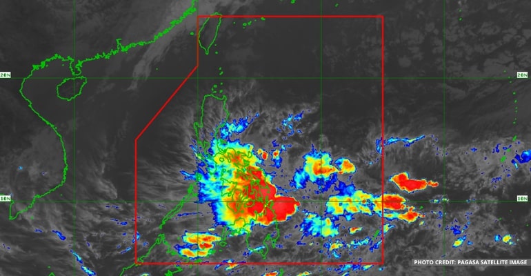
WEATHER UPDATE — According to the Philippine Atmospheric, Geophysical, and Astronomical Services Administration (PAGASA), the Low-Pressure Area (LPA) being monitored has been spotted 140 km east of Hinatuan, Surigao del Sur. The LPA will remain stationary before moving northwards over the weekend.
The weather agency reports the LPA has a wide circulation, bringing rain to Southern Luzon, Visayas, and parts of Mindanao.
Today, the LPA is almost stationary over southern Mindanao. However, due to its broad circulation, it will move somewhere between Visayas and Mindanao on Saturday. Then, on Sunday, it will move further north, between the Bicol Region and Visayas.
On Monday, the LPA may disperse due to the Northeast Monsoon.
Meanwhile, the shear line continues to strengthen the rains brought by the LPA, especially in Eastern Visayas and the Bicol Region. It will continue until Monday or when the LPA disperses.
The Northeast Monsoon, or Amihan, also continues to bring light rains over central Luzon and isolated rain showers over the rest of Luzon.
WEATHER TODAY – JANUARY 13, 2023
For today’s weather forecast, areas in the Bicol Region, specially Albay, Sorsogon, Masbate, Catanduanes, and Romblon, will experience moderate to, at times, heavy rains due to the LPA.
Camarines Provinces, the rest of Mimaropa, and Quezon Provinces are forecast to have cloudy skies with isolated rain showers and thunderstorms brought by the LPA and shear line.
The rest of Luzon, such as Cagayan Valley, Aurora, Calabarzon, and Metro Manila, is forecast to have cloudy skies due to the Northeast Monsoon. Areas in central Luzon, including Ilocos and CAR, may expect the same weather conditions as yesterday, with light isolated rainshowers.
Residents in Eastern and Central Visayas are warned of flash floods and landslides due to the Low-Pressure Area. Heavy rainfall warnings may be issued within the day.
PAGASA also reminds the public that Orange and Red rainfall warnings mean automatic suspension of classes.
On the other hand, the northern portion of Mindanao, including the Zamboanga Peninsula, Northern Mindanao, Caraga Region, Dinagat Islands, and Surigao del Norte, continue to be affected by the LPA. Though there will be less rain than in the previous days, residents are still warned of flash floods and landslides.
The rest of Mindanao, such as the Bangsamoro Region and Davao Region, is forecast to have cloudy skies in the morning and localized thunderstorms by the evening.
PAGASA continues to issue a gale warning to areas in Luzon and Eastern Visayas. Waves are expected to reach up to 4.5 meters. See the full list below:
- Eastern coast of Cagayan
- Isabela
- Aurora
- Northern Quezon, including northern and the Polillo Islands
- Camarines Norte
- Northern coast of Camarines Sur
- Northern and Estern coast of Catanduanes
- Eastern coast of Albay
- Eastern coast of Sorsogon
- Northern Samar
- Eastern Samar
- Eastern coast of Southern Leyte
- Dinagat Islands
- Eastern coast of Surigao del Norte
Watch the 5 am weather update today below:
– WhatALife!
Source: (PAGASA)


Leave a Reply