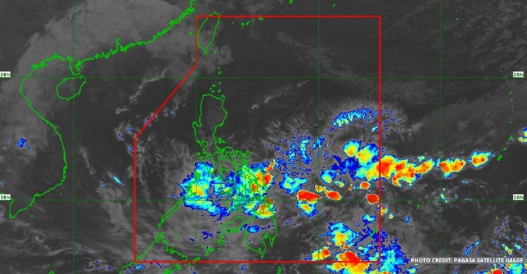
WEATHER UPDATE — According to the Philippine Atmospheric, Geophysical, and Astronomical Services Administration (PAGASA), the Low-Pressure Area (LPA) being monitored has been spotted 380 km east of Surigao City, Surigao del Norte. In addition to the LPA, two weather systems, the Northeast Monsoon and the shear line, are affecting the country.
The weather agency reports the LPA still has a low chance of turning into a tropical storm. However, it will continue to bring rain over Visayas, Mindanao, and even Southern Luzon.
As the shear line strengthens the rain over Southern Luzon and Visayas, the Northeast Monsoon or Amihan affects the Northern and Central portions of Luzon.
The shear line and LPA are forecast to continue bringing rains over the country over the weekend.
WEATHER TODAY – JANUARY 12, 2023
For today’s weather forecast, light to moderate with, at times, heavy rains is expected over Southern Luzon, including Romblon, Sorsogon, and Masbate. Camarines Norte, Camarines Sur, Albay, and Catanduanes are forecast to experience rains from the afternoon until evening.
Meanwhile, Mimaropa may have cloudy skies with light to moderate rains due to the Northeast Monsoon. Aurora, Quezon Provinces, as well as Cagayan Valley, are forecast to have cloudy skies with light rains brought by the Amihan.
The rest of Central Luzon, CAR, Metro Manila, and Calabarzon will experience the same weather as yesterday, with sudden outpours of rain caused by the Northeast Monsoon.
Heavy rains continue to affect Visayas, especially in the eastern and central portions, including Negros Occidental. This is due to the combined presence of the LPA and shear line. As a result, residents are warned against flash floods and landslides.
The rest of Western Visayas is forecast to experience light to moderate with, at times, heavy rains.
Most of Mindanao, including Zamboanga Peninsula, Zamboanga del Norte, Zamboanga del Sur, Northern Mindanao, Lanao del Sur, Caraga Region, Agusan del Norte, Dinagat Islands, and Surigao del Norte, is affected by the shear line, bringing light to moderate with, at times, heavy rains, especially in the evening.
The rest of Mindanao is forecast to have partly cloudy to cloudy skies. Areas in southern Mindanao may expect scattered rainshowers and thunderstorms brought by the LPA.
The weather agency also reminds the public that, per DEPED guidelines, classes are suspended in areas with Orange Rainfall advisories.
PAGASA continues to issue a gale warning to areas in Luzon and Eastern Visayas. Waves are expected to reach up to 4.5 meters. See the full list below:
- Eastern coast of Cagayan
- Isabela
- Aurora
- Northern Quezon, including northern and the Polillo Islands
- Camarines Norte
- Northern coast of Camarines Sur
- Northern and Estern coast of Catanduanes
- Eastern coast of Albay
- Eastern coast of Sorsogon
- Northern Samar
- Eastern Samar
- Eastern coast of Southern Leyte
- Dinagat Islands
- Eastern coast of Surigao del Norte
Watch the 5 am weather update today below:
– WhatALife!
Source: (PAGASA)
Also read: PAGASA: LPA currently near East of Surigao del Sur


Leave a Reply