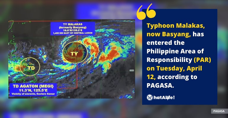
Typhoon Malakas entered the Philippine area of responsibility on Tuesday, April 12, according to the Philippine Atmospheric, Geophysical, and Astronomical Services Administration (PAGASA).
PAGASA stated in its initial report that it arrived at PAR at 10 a.m. Tuesday, April 12. It was also given the local name “Basyang.”
Basyang was located 1,435 kilometers east of Southern Luzon, heading north northwest at 20 kilometers per hour (km/h), according to a report issued shortly before noon on Tuesday by PAGASA.
Basyang is predicted to stay near the PAR boundary, hence it will have a little direct impact on weather in the Philippines. Its stay within PAR will be brief as well, and it might leave on Tuesday evening.
The following areas remained under Tropical Cyclone Wind Signal No. 1:
- Eastern Samar
- Samar
- Northern Samar
- Biliran
- Leyte
- Southern Leyte
- Camotes Island
- Dinagat Islands
In regions covered by TCWS No. 1, strong winds are expected. The winds from Agaton, on the other hand, pose a “minimal to a minor threat to life and property,” according to PAGASA.
Meanwhile, PAGASA’s rain forecast for Agaton stayed the same for the rest of Tuesday. The Weather Bureau warned the public to be prepared for further floods and landslides.
Moderate to heavy rain, with at times intense rain
- Eastern Visayas
- Northern and central parts of Cebu including Bantayan and Camotes Islands
- Aklan
- Capiz
- Iloilo
- Antique
- Guimaras
- Northern and central parts of Negros Occidental
- Northern and central parts of Negros Oriental
- Bicol
Light to moderate rainfall, with some strong downpours
- Rest of Visayas
- Mimaropa
- Quezon
- Dinagat Islands
- Zamboanga del Norte
According to PAGASA, starting Tuesday evening or Wednesday morning, the tropical depression could turn east southeast toward the Philippine Sea.
Moderate to rough seas. Waves ranging from 1.2 to 3.7 meters high are dangerous for tiny boats in remaining Philippine seaboards, particularly the northern and eastern seaboards of Luzon, as well as the eastern seaboards of Visayas and Mindanao
Agaton Forecast track
- Tuesday evening: Over the coastal waters of Guiuan, Eastern Samar
- Wednesday morning: 195 km of Guiuan, Eastern Samar
Basyang Forecast track
- Wednesday morning: 1,515 km east of Northern Luzon (outside PAR)
- Thursday morning: 1,650 km east of extreme Northern Luzon (outside PAR)
- Friday morning: 1,955 km east northeast of extreme Northern Luzon (outside PAR)
- Saturday morning 2,660 km east northeast of extreme Northern Luzon (outside PAR)
– WhatALife!
Source: (philstar.com)
Also read: Agaton still over Samar-Leyte, 9 areas remain under Signal No. 1


Leave a Reply