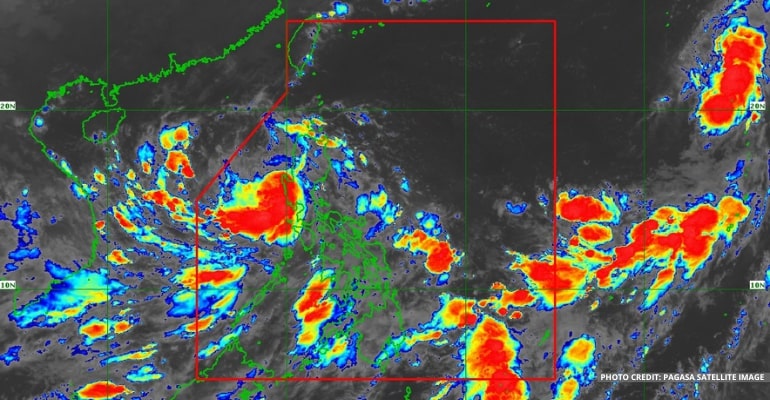
WEATHER UPDATE — According to the Philippine Atmospheric, Geophysical, and Astronomical Services Administration (Pagasa), Typhoon Karding has slightly weakened after landfall in Central Luzon. Meanwhile, the Southwest Monsoon (Habagat) continues to affect Southern Luzon, Visayas, and Western Mindanao.
As of 4 am today, the eye of Typhoon Karding is located at Santa Cruz, Zambales. It has a maximum wind/gust of 140/170 KPH and a faster movement West Northwest at 30 KPH.
By 2 am on Tuesday, Typhoon Karding is expected to leave the Philippine Area of Responsibility (PAR).
“Pagdating ng Tuesday ng madaling araw, 2 am, inaasahan po natin nasa labas na [ang bagyong Karding] ng ating Philippine Area of Responsibility (PAR),” said PAGASA weather specialist Aldczar D. Aurelio.
(At 2 am on Tuesday, we expect that [Typhoon Karding] will be out of our Philippine Area of Responsibility.)
At the moment, the whole country is experiencing cloudy skies and rain showers. However, no Low-Pressure Area (LPA) is seen inside PAR.
For today’s weather forecast, Zambales, Bataan and Tarlac should expect heavy to intense with, at times, torrential rains until noon today. Meanwhile, the western portion of Pangasinan, Pampanga, Cavite, and Lubang Islands may expect moderate to heavy with, at times, intense rains.
Light to moderate with at times heavy rains are also expected over Metro Manila, the rest of Pangasinan, La Union, Benguet, Nueva Vizcaya, Nueva Ecija, Bulacan, Rizal, Laguna, and the western portion of Batangas and mainland Occidental Mindoro.
Tropical Cyclone Wind Signal
The latest Tropical Cyclone Wind Signal updates are as follows:
Signal No. 3:
- The western section of Pangasinan
- The northern and central portions of Zambales
Signal No. 2:
- The rest of Pangasinan
- La Union
- The southern portion of Benguet
- Tarlac
- The western portion of Nueva Ecija
- Pampanga
- The rest of Zambales
- The northern portion of Bataan
Signal No. 1:
- Ilocos Sur
- The rest of Benguet
- The western portion of Ifugao
- The western portion of Mountain Province
- Quirino
- Nueva Vizcaya
- The central and southern portions of Aurora
- The rest of Nueva Ecija
- Bulacan
- The rest of Bataan
- Metro Manila
- The extreme northern portion of Quezon
- The western portion of Batangas
- Cavite
- The northern portion of Occidental Mindoro, including the Lubang Islands
Watch the 5 am PAGASA weather forecast below:
– WhatALife!
Source: (PAGASA)
Also read: PAGASA: LPA near PAR may become Tropical Depression over the weekend to be named ‘Karding’


Leave a Reply