WEATHER UPDATE — According to the Philippine Atmospheric, Geophysical, and Astronomical Services Administration (Pagasa), the Tropical Storm with the international name NANMADOL may enter PAR (Philippine area of responsibility) tomorrow morning. It will be the tenth storm this 2022 and the second for the month of September.
When inside the PAR, it will go through the northern part of the Philippine sea, where it will stay inside for less than 24 hours, and by the weekend, the storm will have exited the PAR. However, the storm is also intensifying very quickly; by this day, it may grow into a Severe Tropical Storm, and by the time it enters the PAR, it has a chance of becoming a Typhoon.
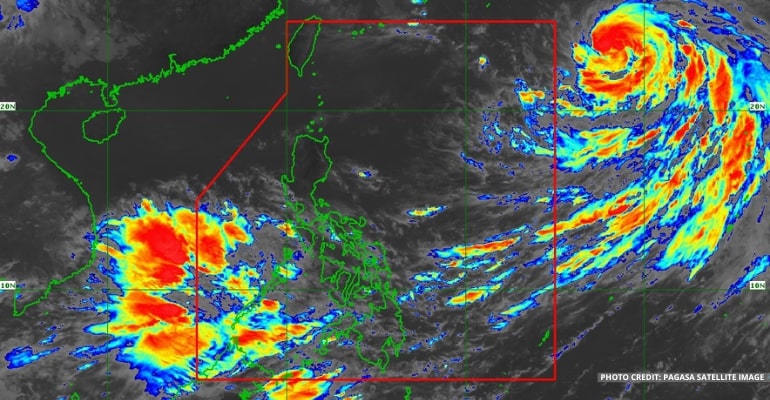
Tropical Storm NANMADOL is now located 1,850 km East of Extreme Northern Luzon (23.1°N, 139.6°E) with maximum sustained winds of 95 km per hour near the center and gustiness of up to 115 km per hour. It is moving Northwestward at 15 km per hour.
“Itong trough or yung extension nitong si bagyong NANMADOL bagamat kung mapapansin natin ay hindi ito direktang nakakaapekto sa ating bansa. Ang nakakaapekto instead ay yung Habagat o yung Southwest Monsoon na siyang pinalalakas nitong si bagyong NANAMADOL,” PAGASA forecaster Benison Estareja said.
(The trough or extension of tropical storm NANMADOL does not directly affect our country. What it affects instead is the Habagat or the Southwest Monsoon, which tropical storm NANAMADOL is strengthening.)
The Southwest Monsoon affects a large portion of Southern Luzon, Visayas, and the western section of Mindanao.
For today’s weather forecast, Zambales, Bataan, Occidental Mindoro, Palawan, Aklan, Antique, Negros Occidental, Zamboanga Peninsula, Basilan, Sulu, and Tawi-Tawi will have cloudy skies with scattered rain showers and thunderstorms, with the possibility of flash floods or landslides due to moderate to at times heavy rains.
Meanwhile, Metro Manila and the rest of the country will have partly cloudy to cloudy skies with isolated rain showers or thunderstorms, with the possibility of flash floods or landslides during severe thunderstorms.
Winds will be moderate in Southern Luzon, Visayas and the western section of Mindanao, moving southwest to west, while coastal waters will be moderate; winds will be light to moderate in Northern and Central Luzon, moving northwest to the west, while coastal waters will be slight to moderate; and winds will be light to moderate in the rest of Mindanao, moving southwest to west and coastal waters will be slight to moderate.
Watch the 5 AM weather update today below:
– WhatALife!/Zed
Source: (PAGASA)
Also read: PAGASA: Tropical Depression now Tropical Storm JOSE


Leave a Reply