WEATHER UPDATE — According to the Philippine Atmospheric, Geophysical, and Astronomical Services Administration (Pagasa), Metro Manila, Ilocos Region, Cordillera Administrative Region, CALABARZON, MIMAROPA, Bicol Region, Western Visayas, Batanes, Cagayan, Zambales, and Bataan will have cloudy skies with scattered rain showers or thunderstorms, with the possibility of flash floods or landslides due to moderate to at times heavy rains.
Tropical Depression “GARDO” was estimated, based on all available data, at 920 km East Northeast of Extreme Northern Luzon (24.2°N, 130.0°E) with maximum sustained winds of 55 km/h near the center and gustiness of up to 70 km/h. It is moving Northwestward at 45 km/h.
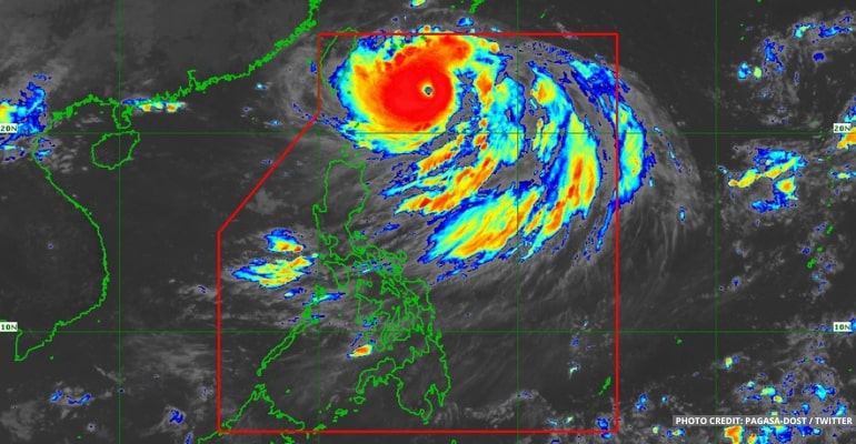
Meanwhile, the Super Typhoon Henry (international name “HINNAMNOR”) is located 560 km East of Itbayat, Batanes (23.5°N, 126.4°E) with maximum sustained winds of 185 km/h near the center and gustiness of up to 230 km/h. It is moving Southwestward at 25 km/h.
“Kung mapapansin po niyo dito sa ating latest satellite animation, ay halos magkalapit na po sa isat-isa itong dalawang bagyo, at kitang-kita yung pagiging malakas nitong si super typhoon Henry kumpara dito kay tropical depression Gardo,” PAGASA forecaster Benison Estareja added, “…kaya nakikita po natin sa mga susunod na oras ay posibleng humina pa itong si tropical depression Gardo… at i-absorb o higupin na lamang nitong si super typhoon Henry at malusaw.”
(If you notice in our latest satellite animation, these two storms are almost close to each other, and it is obvious that super typhoon Henry is stronger compared to tropical depression Gardo… so we can see in the next few hours it is possible that this tropical depression Gardo will weaken… and just be absorbed by the Super Typhoon Henry and dissolve.)
Winds will be strong throughout Northern Luzon, moving northwest to west, and coastal waters will be rough.
Winds will also be light to moderate in the rest of the country, moving from the west to the southwest. Additionally, coastal waters will be slight to moderate.
Watch the 5 AM weather update today below:
– WhatALife!/Zed
Source: (PAGASA)
Also read: PAGASA: Tropical Depression “GARDO” within PAR; Super Typhoon “HINNAMNOR” outside PAR


Leave a Reply