On Wednesday morning, August 24, Philippine Atmospheric, Geophysical and Astronomical Services Administration (PAGASA) announced in a press briefing that Florita (Ma-on) is now out of the PAR (Philippines Area of Responsibility).
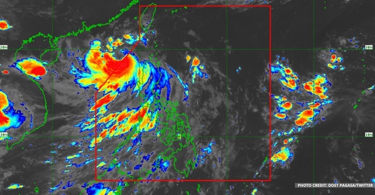
At 4:00 AM today, based on all available data, PAGASA reported that the Severe Tropical Storm “FLORITA” (international name MA-ON) was estimated to be 245 km West Northwest of Laoag City, Ilocos Norte, or 310 km West of Calayan, Cagayan (19.2°N, 118.5°E), with a maximum sustained winds of 95 kph near the center with gustiness of up to 115 kph. It is also moving West Northwestward at 30 kph.
“And even though the storm Florita is outside the Philippine area of responsibility, its reach or radius is widespread and still extends to some areas of Northern Luzon,” PAGASA forecaster Grace Castañeda said.
She said that PAGASA will continue to issue Tropical Cyclone Bulletin for areas that will still experience strong winds and rains due to the storm Florita.
“To this day, we can still expect the storm will enhance the Southwest Monsoon, which itself will cause rains in a large portion of our country,” she added.
According to Ilocos Region and Cordillera Administrative Region forecast, these areas will experience rains with gusty winds. Due to gusty rains, they could experience possible flash floods or landslides due to moderate to heavy rains. In addition, very light to light damage to structures and vegetation is possible due to moderate to strong winds.
The rest of the Bataan, Zambales, Oriental Mindoro, and Occidental Mindoro will experience cloudy skies with scattered to widespread rains and thunderstorms, and flash floods or landslides are possible due to moderate to heavy rains. On the other hand, very light to light damage to structures and vegetation is likely due to moderate to strong winds.
Metro Manila and the rest of Luzon will experience cloudy skies with scattered rain showers and thunderstorms. On the other hand, the rest of the country will experience partly cloudy skies with isolated rain showers or thunderstorms.
Northern and Central Luzon will also expect strong winds and Moderate to Rough waves at 3.4 to 5.0 meters. Meanwhile, the rest of Luzon can expect Moderate to Strong winds and Moderate to Rough waves at 1.2 to 2.8 meters.
Light to moderate winds and waves of between 0.6 and 2.5 meters will also occur in the rest of the country.
See the latest PAGASA weather forecast below:
–WhatALife!/Zed
Also read: PAGASA: “Florita” from Tropical Storm to Severe Tropical Storm


Leave a Reply