On Tuesday morning, August 23, PAGASA (Philippine Atmospheric, Geophysical and Astronomical Services Administration) announced in a press briefing that ‘Florita’ has strengthened enough to go from the Tropical Storm Category to the Severe Tropical Storm Category.
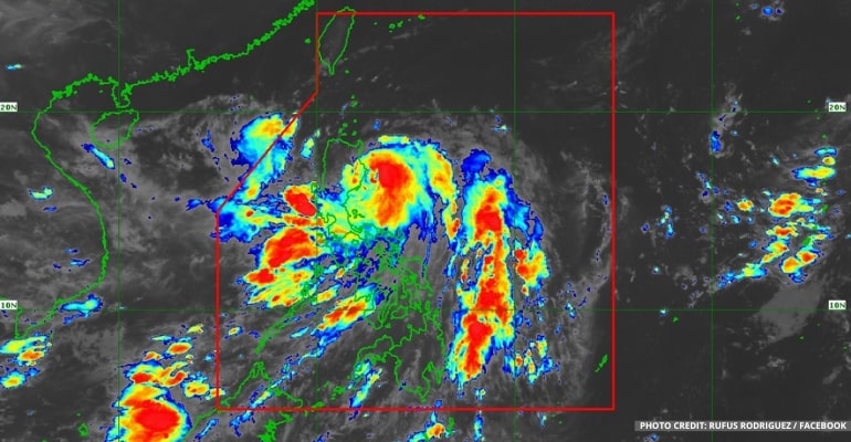
At 3:00 AM today, PAGASA reported based on all available data that the center of Severe Tropical Storm “FLORITA” {international name MA-ON} was estimated at 115 km East of Casiguran, Aurora (16.4°N, 123.2°E) with a maximum sustained winds of 95 km/h near the center and gustiness of up to 115 km/h. It is moving North Northwestward at 10 km/h.
“We still expect the storm to be near the land, especially in the eastern section of Northern and Central Luzon,” PAGASA said.
The Southwest Monsoon (Habagat) is still affecting Southern Luzon and Visayas.
Moreover, according to the forecast for Cagayan Valley, Cordillera Administrative Region, Ilocos Norte, and Ilocos Sur, these areas will experience stormy weather. Due to stormy rains, they could experience possible flash floods or landslides due to heavy – torrential rains. Moderate to heavy damage to structures and vegetation is possible due to damaging to destructive storm-force winds.
The rest of the Ilocos Region, Aurora, Nueva Ecija, Quezon, and Camarines Norte will experience rains with gusty winds, and flash floods or landslides are possible due to moderate to heavy rains. Very light to light damage to structures and vegetation is possible due to moderate to strong winds.
Metro Manila, the rest of Luzon, and Visayas will experience cloudy skies with scattered rain showers and thunderstorms.
On the other hand, Mindanao will experience partly cloudy skies with isolated rain showers or thunderstorms.
Northern Luzon will also expect some Strong winds and Moderate to Rough waves at 3.4 to 5.0 meters. Meanwhile, Central and Southern Luzon and the western section of Visayas can expect Moderate to Strong winds and Moderate to Rough waves at 2.5 to 4.0 meters.
The rest of the country will also have Light to Moderate winds and Slight to Moderate waves at 0.6 to 2.5 meters.
See the latest PAGASA weather forecast below:
–WhatALife!/Zed
Also read: Severe Tropical Storm Florita Signal Number Update as of August 23, 2022


Leave a Reply