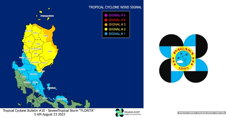
On Tuesday morning, August 23, PAGASA (Philippine Atmospheric, Geophysical and Astronomical Services Administration) announced in a press briefing the signal number update for the areas affected by Severe Tropical Storm Florita:
SIGNAL NO. 3
The Northern and Eastern portions of mainland Cagayan and the Eastern portion of Isabela are in Tropical Cyclone Wind Signal No. 3.
SIGNAL NO. 2
The rest of Cagayan, including Babuyan Islands, the rest of Isabela, Quirino, the Eastern and Central portins of Nueva Vizcaya, Apayao, Abra, Kalinga, Mountain Province, Ifugai, Northern portion of Benguet, Ilocos Norte, Ilocos Sur, and the Northern and Central portions of Aurora are in Tropical Cyclone Wind Signal No. 2.
SIGNAL NO. 3
For Batanes, the rest of Nueva Vizcaya, the rest of Benguet, La Union, Pangasinan, the Eastern portion of Tarlac, Nueva Ecija, the rest of Aurora, the Eastern portion of Pampanga, the Eastern portion of Bulacan, the Eastern portion of Rizal, the Northern portion of Quezon, including Polillo Islands, the Northern portion of Laguna, and Camarines Norte are in Tropical Cyclone Wind Signal No. 1.
See official tweet by PAGASA-DOST below:
Expect Heavy Rainfall, PAGASA says
Heavy to intense, at times, torrential rains expected over Cagayan, Isabela, CAR (Cordillera Administrative Region), Ilocos Region, and Zambales. Meanwhile, moderate to heavy with, at times, heavy rains are expected over the northern portion of Aurora, Bataan, Tarlac, and the rest of Cagayan Valley, and light to moderate with at times heavy rains over Metro Manila, CALABARZON, Camarines Norte, and the rest of Central Luzon.
Expect tomorrow early morning to afternoon, heavy to intense with at times torrential rains over the Ilocos Region, moderate to heavy with at times heavy rains over Benguet and Abra, and light to moderate with at times heavy rains over the rest of CAR.
“On the other hand, rains are still expected due to the Southwest Monsoon.” PAGASA forecaster Aldczar Aurelio reported.
In the next 24 hours, the areas that will experience Light to Moderate to sometimes Heavy rain due to the Southwest Monsoon (Habagat) include the Western Visayas, MIMAROPA, and the rest of the Bicol Region.
PAGASA cautions people to remain careful, alert, and ready for possible scattered to widespread flooding, including flash floods and rain-induced landslides, especially in localities with significant antecedent rainfall and in areas that are highly or very highly susceptible to these hazards as identified in hazard maps. –WhatALife!/Zed
Also read: PAGASA: Tropical Depression “FLORITA” near East of Casiguran, Aurora


Leave a Reply