The weather state bureau raised the Tropical Cyclone Wind Signal (TCWS) No. 1 in over 23 areas on Tuesday, October 20, due to Tropical Depression Pepito.
The areas under TCWS No. 1 are as follows:
Isabela
Quirino
Nueva Vizcaya
Abra
Kalinga
Mountain Province
Ifugao
Benguet
Ilocos Sur
La Union
Pangasinan
Aurora
Nueva Ecija
Tarlac
Zambales
Bulacan
Pampanga
Bataan
Metro Manila
Rizal
The northern portion of Quezon (General Nakar, Infanta, Real) including Polillo Islands
The extreme northern portion of Camarines Norte (Vinzons),
and Catanduanes
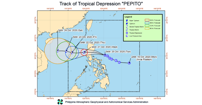
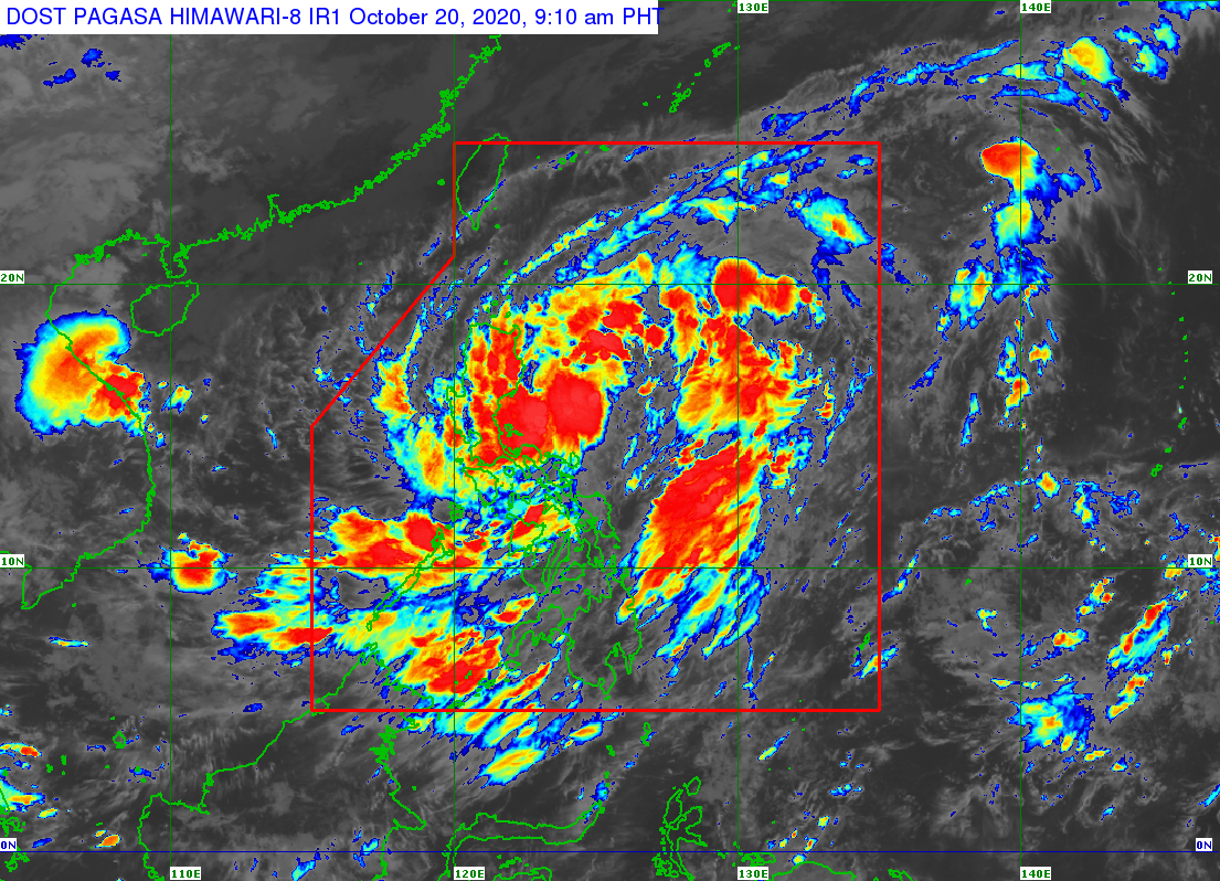
The Philippine Atmospheric, Geophysical, and Astronomical Services Administration (PAGASA) reported that Pepito continues to move west-northwestward over the Philippine sea east of Central Luzon.
As of 7 AM on Tuesday, the center of Tropical Depression Pepito was estimated at 373 kilometers east of Infanta, Quezon, or 385 km East of Baler, Aurora.
It has maximum sustained winds of 55 kilometers per hour near the center and gustiness of up to 70 kph moving west-northwestward at 25 kph.
“‘PEPITO’ will move west-northwestward today and make landfall over the coast of the Aurora-Isabela area tonight. It will then cross the Luzon landmass and emerge over the West Philippine Sea tomorrow morning,” PAGASA reported.
This tropical cyclone may exit the PAR on Thursday (October 22) morning.
Image source: PAGASA
It will bring moderate to heavy rains over Bicol Region, Marinduque, Romblon, Quezon, Aurora, Nueva Ecija, Nueva Vizcaya, Quirino, Isabela, mainland Cagayan, Pangasinan, and Benguet.
Meanwhile, light to moderate with at times heavy rains will be experienced over Metro Manila, Cordillera Administrative Region, MIMAROPA, Western Visayas, Zamboanga Peninsula, Bangsamoro, Northern Mindanao, and the rest of Ilocos Region, Cagayan Valley, Central Luzon, CALABARZON, and MIMAROPA.
Flooding, including flash floods and rain-induced landslides, may occur during heavy or prolonged rainfall, especially in high or very highly susceptible areas to these hazards.
High winds, strong to a near gale, will be experienced in areas under TCWS No. 1. High winds to gale-force winds with occasional gusts due to the northeasterly surface wind flow will be experienced over Batanes, Babuyan Islands, and the coastal and/or mountainous areas of mainland Cagayan, Apayao, and Ilocos Norte.
A gale warning was raised over the seaboards of Batanes, Cagayan, Isabela, Ilocos Norte, and Ilocos Sur due to rough to very rough seas.
The seaboards of areas under TCWS No. 1 will also experience rough to very rough seas. Sea travel is risky over these areas, especially for those using small seacraft.
Moderate to rough seas will prevail over the western and eastern seaboards of Southern Luzon and Eastern Visayas, Caraga, and Davao Region.
Those with small seacraft are advised to take precautionary measures when venturing out to sea. Inexperienced mariners should avoid navigating in these conditions.
—(Source: PAGASA)
Blayce helped launch WhatALife! Blog in late May 2019, publishing trendy lifestyle and entertainment articles, local and international news reports, as well as inspiring feature stories of successful individuals hailing from Cagayan de Oro City. A jack-of-all-trades, she is a part-time gamer, occasional guitar player, and a zombie-genre fanatic.


Leave a Reply