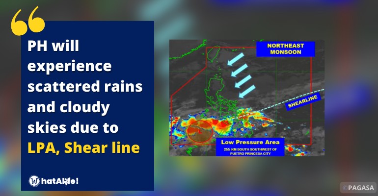
According to PAGASA, the Low Pressure Area (LPA) was projected to be 465 kilometers west of Zamboanga City or 255 kilometers south southwest of Puerto Princesa City on Thursday, with the shear line hitting Visayas and the northeast monsoon affecting Luzon.
The LPA/shear line will bring cloudy skies, scattered rainshowers, and thunderstorms to Visayas, Mindanao, and Palawan, with possible flash floods or landslides due to moderate to heavy rains.
The northeast monsoon will bring cloudy skies and light rainfall to the Cagayan Valley, Cordillera Administrative Region, Bicol Region, rest of MIMAROPA, Aurora, and Quezon.
Northern Luzon, as well as the eastern regions of central and southern Luzon, will have moderate to severe northeasterly winds, with moderate to rough coastal waves.
The rest of Luzon and the Visayas will have moderate to severe winds from the northeast to the north, with moderate to rough coastal waves.
The forecast temperature range for major cities or areas as follows:
| Metro Manila | 24 to 31 degrees Celsius |
| Baguio City | 14 to 25 degrees Celsius |
| Laoag City | 22 to 32 degrees Celsius |
| Tuguegarao | 21 to 28 degrees Celsius |
| Legazpi City | 24 to 29 degrees Celsius |
| Puerto Princesa City | 25 to 31 degrees Celsius |
| Tagaytay | 22 to 28 degrees Celsius |
| Kalayaan Islands | 26 to 31 degrees Celsius |
| Iloilo City | 25 to 29 degrees Celsius |
| Cebu | 24 to 31 degrees Celsius |
| Tacloban City | 25 to 28 degrees Celsius |
| Cagayan De Oro City | 24 to 29 degrees Celsius |
| Zamboanga City | 25 to 31 degrees Celsius |
| Davao City | 25 to 31 degrees Celsius |
Watch the 4 AM weather update today below:
– WhatALife!
Source: (PAGASA)
Also Read: LPA, Shear Line, brings scattered rains and cloudy skies in a large portion of PH


Leave a Reply