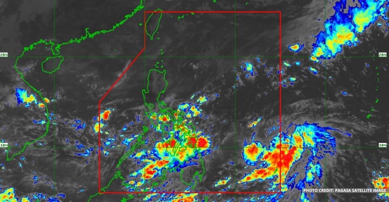
WEATHER UPDATE — According to the Philippine Atmospheric, Geophysical, and Astronomical Services Administration (Pagasa), the LPA east of Eastern Visayas has developed into a Tropical Depression “Paeng.” Bagyong PAENG may intensify into a Tropical Storm on Thursday.
Bagyong PAENG turned into a Tropical Depression at 8:00 am today, October 26, 2022. It is forecast to intensify into a tropical storm category tomorrow and may likely reach the typhoon category on Saturday. Further intensification is possible while it moves over the Philippine Sea.
Tropical Depression PAENG has maximum sustained winds of 45 km/h near the center, gustiness of up to 55 km/h, and a central pressure of 1004 hPa.
At present, it is moving west-northwestward slowly. Moreover, its strong winds extend outwards up to 300 km from the center.
Due to the Shear Line and the trough of Bagyong PAENG, heavy rains may be expected over Quezon, the Bicol Region, Visayas, and the northern and western portions of Mindanao.
WEATHER FORECAST DUE TO BAGYONG PAENG
From Friday morning through Saturday morning, the following areas will experience heavy to intense with, at times, torrential rains:
- Bicol Region
Moderate to heavy with, at times, intense rains:
- Eastern Visayas
- Mindoro Provinces
- Marinduque
- Romblon
- Quezon
- Aurora
- Isabela
- Cagayan
Light to moderate with, at times, heavy rains:
- Rizal
- Laguna
- Nueva Ecija
- Bulacan
- Cordillera Administrative Region (CAR)
- the restof Visayas and Cagayan Valley
From Saturday morning through Sunday, the following areas will experience heavy to intense with, at times, torrential rains:
- Cagayan
- Isabela
- Apayao
- the northern portion of Aurora
Moderate to heavy with, at times, intense rains:
- Ilocos Norte
- the rest of Aurora, Cagayan Valley, and CAR
Light to moderate with, at times, heavy rains:
- Western Visayas
- the rest of Luzon
TROPICAL CYCLONE WIND SIGNAL UPDATES
As of the moment, no Tropical Cyclone Wind Signal is hoisted. However, per the latest track and intensity forecast, the most likely highest wind signal to be hoisted is Wind Signal No. 4.
Please refer to your local PAGASA Regional Services Division for updates. – WhatALife!
Source: (PAGASA)
Also read: PAGASA: Shear line, Amihan, LPA bring weather disturbance


Leave a Reply