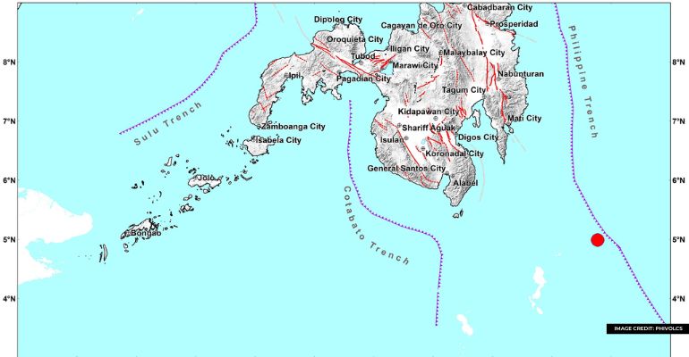
MANILA, Philippines – Tuesday morning, the Philippine Institute of Volcanology and Seismology (Phivolcs) reported a 6.7 magnitude earthquake striking the waters near Sarangani Island in Davao Occidental.
Phivolcs initially stated that the seismic activity in the area measured a magnitude of 7.1. The earthquake, classified as tectonic in nature, occurred 183 kilometers (km) southeast of Balut Island in Sarangani Island, according to Phivolcs’ report.
Here are the following places who experienced the earthquake:
- Intensity IV- Glan, Malungon, and Kiamba, Sarangani
- Intensity III – General Santos City; City of Koronadal, Tupi, Polomolok, and T’boli, South Cotabato; Alabel, and Malapatan, Sarangani; Matalan, Cotabato
- Intensity II – Tampakan, Tantangan, Banga, Norala, Santo Niño, Surallah, and Lake Sebu, South Cotabato; Zamboanga City; Maitum, Sarangani; City of Kidapawan, Makilala, M’lang, Pigcawayan, Tulunan, and Kabacan, Cotabato; President Quirino, Sultan Kudarat
- Intensity I – Cagayan de Oro City; Maasim, Sarangani; Arakan, Cotabato; Isulan, Sultan Kudarat
Meanwhile, Phivolcs recorded the following instrumental intensities:
- Intensity IV- Malungon, Alabel, Kiamba, and Glan, Sarangani
- Intensity III- City of Koronadal, Tupi, and T’boli, South Cotabato; Malapatan, Sarangani; Nabunturan, Davao de Oro; Don Marcelino, Davao Occidental; City of Digos, Davao del Sur; City of Gingoog, Misamis Oriental
- Intensity II- Banga, Norala, Lake Sebu, Santo Niño, Tantangan, and Tampakan, South Cotabato; Maitum, and Malungon, Sarangani; Columbio, President Quirino, Lambayong, Lebak, and Esperanza, Sultan Kudarat; Davao City; Magsaysay, and Matanao, Davao del Sur; Zamboanga City; San Fernando, Bukidnon; City of Kidapawan, Cotabato
- Intensity I – Malaybalay, Kadilingan, and Kalilangan, Bukidnon; Banisilan, Carmen, Magpet, and President Roxas, Cotabato; Balingasag, Misamis Oriental; Bagumbayan and Isulan, Sultan Kudarat; City of Bislig, Surigao del Sur
Phivolcs stated that while no significant damage is anticipated, there is a possibility of aftershocks. According to their initial bulletin released at 4:57 a.m., PHIVOLCS identified the epicenter of the tectonic earthquake, which occurred at 4:48 a.m., as being 119 kilometers southeast of Sarangani Island. The earthquake had a focal depth of 76 kilometers.
Also R ead: Residents gather sardines washed ashore in Sarangani


Leave a Reply