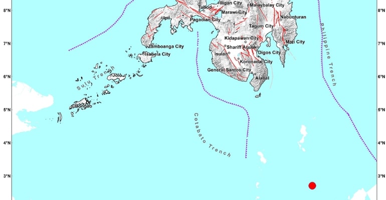
DAVAO, PHILIPPINES — A magnitude 7.0 offshore earthquake was recorded at 2:06 PM yesterday, January 18. The tectonic earthquake originated 346 km from Balut Island, Municipality of Sarangani, Davao Occidental.
The Philippine Institute of Volcanology and Seismology reported the earthquake had a depth of focus of 40 KM with the following Reported Intensities:
- Intensity II – Glan, Maasim, and Malungon, Sarangani; Banga, City of Koronadal,
- Polomolok, Tampakan, and Tupi, South Cotabato; City of General Santos;
- Kalamansig, Palimbang, and President Quirino, Sultan Kudarat
- Intensity I – Lake Sebu, and Surallah, South Cotabato; Columbio, Sultan Kudarat
Instrumental Intensities:
- Intensity II – Nabunturan, Davao de Oro; Don Marcelino, Davao Occidental;
- City of Kidapawan, Cotabato; Glan, and Kiamba, Sarangani; City of Koronadal,
- Santo Niño, T’Boli, and Tupi, South Cotabato; City of General Santos
- Intensity I – City of Zamboanga; Maasim, and Maitum, Sarangani; Lake Sebu, Norala,
- Surallah, Tampakan, and Tantangan, South Cotabato; Isulan, Sultan Kudarat
Magnitude 7.0 offshore earthquake shakes Indonesia
On Wednesday, a magnitude 7.0 offshore earthquake hit near eastern Indonesia’s Maluku Islands, according to the US Geological Survey (USGS). It triggered a tsunami warning but was later lifted.
The quake occurred at around 1:06 PM local time (2:06 PM in Manila). It shook nearby islands, which forced residents to flee in panic.
The head of Indonesia’s earthquake agency and tsunami center, Daryono, reported that five aftershocks followed the tremor; the strongest they recorded was a 5.3 magnitude aftershock. – WhatALife!
Also read: Indonesia earthquake kills more than 160 people, most were children

Leave a Reply