On the evening of October 16, the second-largest island of the Philippines suddenly experienced a tremblor. With the highest intensity centered in Kidapawan City at Intensity 7, it immediately sent hundreds of people out from high-rising buildings, as well as residences. Even those areas who felt Intensities 2 and 3.
Although there were still damages and a few who lost their lives, the quick response of the affected citizens, not to mention the prompt emergency evacuations, somehow reduced life casualties.
From earthquake drills to proper information dissemination, the gradual progress of the Philippines in terms of disaster risk reduction over the years has been apparent.
Nevertheless, where we are today is, unfortunately, made possible because of the tragic catastrophe our fellowmen experienced. A lesson learned from one of the strongest, most devastating earthquakes recorded in the country’s history—the 1976 Moro Gulf Earthquake.
The Midnight Killer
As the clock stroke 11 minutes past midnight of August 17, a destructive earthquake suddenly shook the island of Mindanao. Its epicenter located near the town of Lebak, Sultan Kudarat, with a magnitude of 7.9.
Dubbed as the Midnight Killer, the 1976 Moro Gulf Earthquake took away around 8,000 lives. Most of the casualties came from the residents living near the coastal areas.
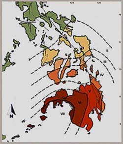
Summary field report from PAGASA /PHIVOLCS
Intensity VII – Cotabato City; Jolo-Sulu; Zamboanga City
Intensity VI – Basilan City; Pagadian City; Dipolog City; Malaybalay-Bukidnon
Intensity V – Cagayan de Oro City; Davao City; General Santos City
Intensity IV – Dumaguete City; Hinatuan Surigao del Sur; Tagbilaran-Bohol; Cebu City; Surigao-Surigao del Norte
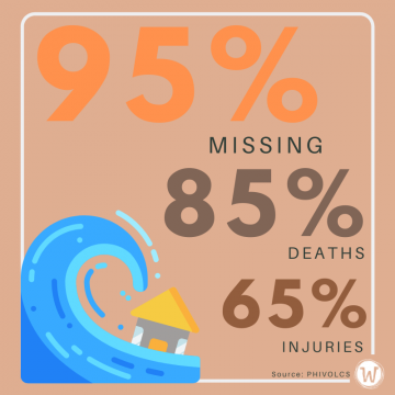
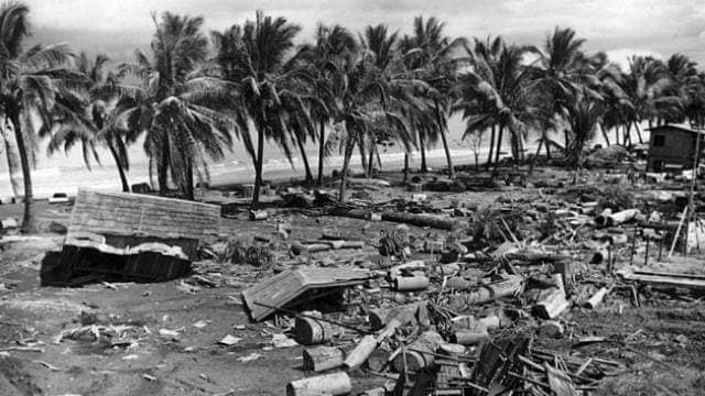
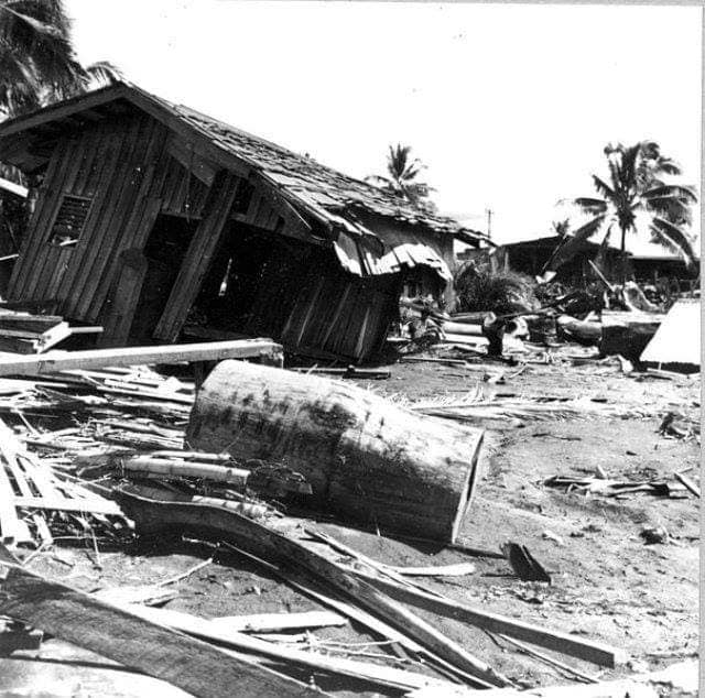
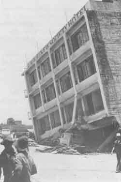
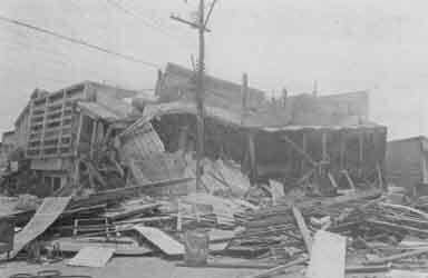
Although the violent quake had torn down poorly structured buildings, 95 percent of the fatalities were the result of a 9-meter (29-30 feet) high tsunami.
This offshore event generated by the Cotabato trench, a less prominent trench system in the Philippines, was the largest tsunamigenic earthquake to have occurred in Mindanao in the last two decades. It was an earthquake that resulted in massive destruction of properties and a great loss of lives. (Philippine Institute of Volcanology and Seismology – PHIVOLCS)
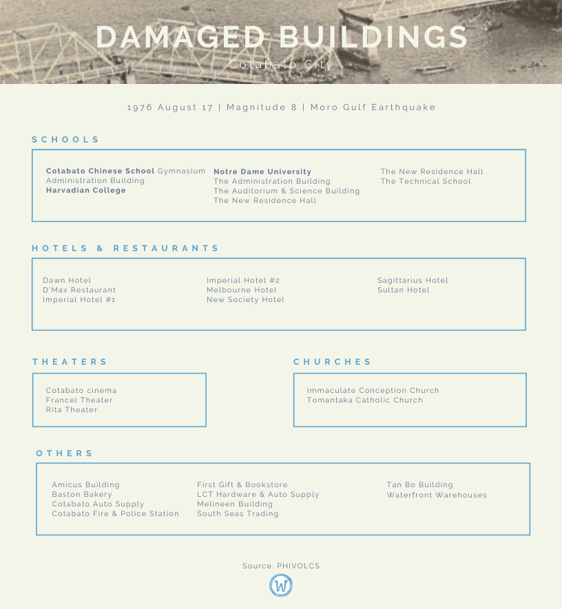
The cities and provinces of Cotabato had the most casualties from the earthquake while the spawned tsunami swept over the provinces bordering the Moro Gulf, especially on the shores of Pagadian City.
Lack of awareness of potential danger—most homes in coastal areas remained on their homes, did not seek higher grounds despite the 5-15 minutes interval before the waves came.
PHIVOLCS recorded an average of roughly 140 aftershocks per day, starting on the 18th of August 1976.
In a 2015 interview, PHIVOLCS Director Renato Solidum said that tsunamis in the Philippines are more dangerous compared to those that occur in our neighboring countries.
“The tsunamis in our country arrive much faster than those in Indonesia and Japan because the source of the earthquake or the trenches are closer to the shorelines. If the trenches are closer to the shoreline, then the source of the tsunami will be much closer to the shoreline, so the distance will only be short and the lead time will be shorter,” Solidum explained.
Solidum noted that despite having these advanced technologies today, vigilance and readiness of local communities still stand as necessary. Especially on how people will respond to it. He also added how the adversity served as a lesson for local communities on disaster preparedness.
It is a very good example of a threat of a sudden onset of an event after an earthquake that people need to know… People need to know which areas will be affected, where they will go if they will be evacuated and where the safe evacuation centers should be located.
—PHIVOLCS Director Renato Solidum (Rappler.com)
Overall Casualties
The following are from PHIVOLCS‘ 1976 report:
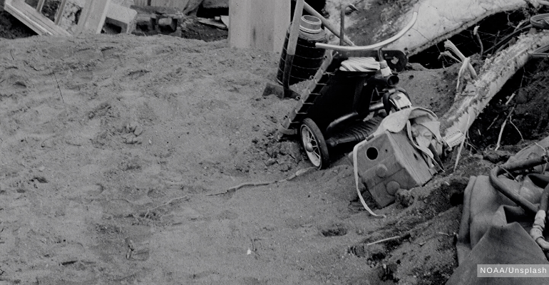
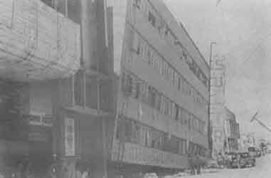
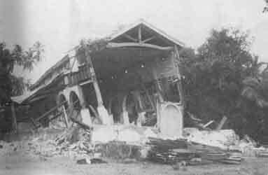
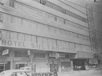
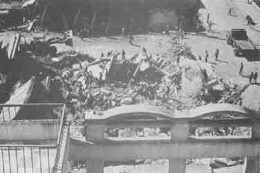
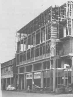
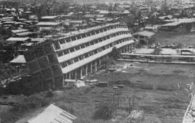
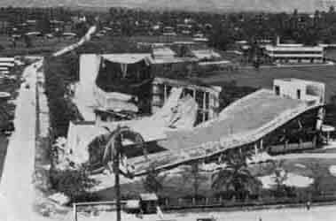
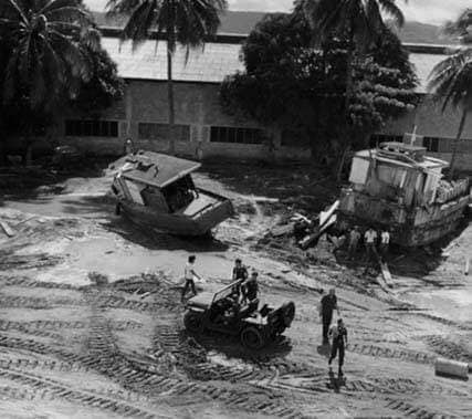
The photographs shown below were taken from a survey conducted by the International Tsunami Information Center (ITIC) then-Director Dr. George Pararas-Carayanniz and his Associate Director Sydney Wigen. In collaboration with the Philippine Atmospheric, Geophysical, and Astronomical Services Administration (PAGASA) administrator Dr. Roman Kintanar and Commodore Jayma Presbitero, as well as the Director of the Coast and Geodetic Survey and staff members.
—
Yes, apparently, nothing would ever beat this dreadful natural phenomenon. BUT continuously educating the people on these disasters, on what to do, can most likely increase the survival rate—just in case it happens.
Especially earthquakes that are classified to be unpredictable—all that is left for us, apart from ensuring the safety of structures, is to be vigilant.
Blayce helped launch WhatALife! Blog in late May 2019, publishing trendy lifestyle and entertainment articles, local and international news reports, as well as inspiring feature stories of successful individuals hailing from Cagayan de Oro City. A jack-of-all-trades, she is a part-time gamer, occasional guitar player, and a zombie-genre fanatic.
 Lack of awareness of potential danger—most homes in coastal areas remained on their homes, did not seek higher grounds despite the 5-15 minutes interval before the waves came.
 The photographs shown below were taken from a survey conducted by the International Tsunami Information Center (ITIC) then-Director Dr. George Pararas-Carayanniz and his Associate Director Sydney Wigen. In collaboration with the Philippine Atmospheric, Geophysical, and Astronomical Services Administration (PAGASA) administrator Dr. Roman Kintanar and Commodore Jayma Presbitero, as well as the Director of the Coast and Geodetic Survey and staff members.
 —
Yes, apparently, nothing would ever beat this dreadful natural phenomenon. BUT continuously educating the people on these disasters, on what to do, can most likely increase the survival rate—just in case it happens.
Especially earthquakes that are classified to be unpredictable—all that is left for us, apart from ensuring the safety of structures, is to be vigilant.
—
Yes, apparently, nothing would ever beat this dreadful natural phenomenon. BUT continuously educating the people on these disasters, on what to do, can most likely increase the survival rate—just in case it happens.
Especially earthquakes that are classified to be unpredictable—all that is left for us, apart from ensuring the safety of structures, is to be vigilant.
Leave a Reply