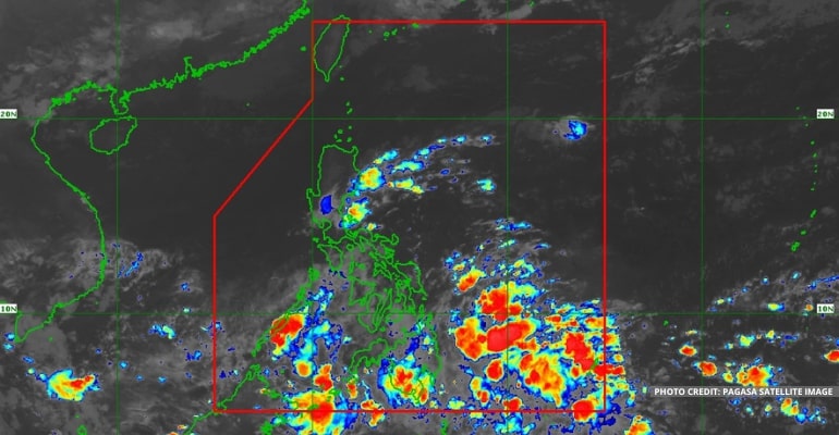
WEATHER UPDATE — According to the Philippine Atmospheric, Geophysical, and Astronomical Services Administration (Pagasa), the ITCZ (Intertropical Convergence Zone) and the Trough of LPA (Low-Pressure Area) within the ITCZ is affecting Mindanao. Meanwhile, the Shear Line is affecting the eastern portion of Luzon.
The LPA being monitored by Pagasa is now located 200 km South Southeast of General Santos City (4.5°N, 126.0°E) by 3 am. Therefore, the LPA is now outside the PAR (Philippine Area of Responsibility), at its boundary, and within the ITCZ.
“Nasa labas na ito ng ating Philippine Area of Responsibility at nakapaloob ito sa Intertropical Convergence Zone o ITCZ,” said PAGASA Weather Forecaster Daniel James Villamil.
(It is outside our Philippine Area of Responsibility, and it is contained in the Intertropical Convergence Zone or ITCZ)
The LPA will unlikely become a full-fledged storm in the next 24 hours. However, two to three storms are expected to form in the PAR for November.
Due to this weather system, Mindanao and Palawan will experience cloudy skies with scattered rainshowers and thunderstorms.
WEATHER TODAY – November 17, 2022
For today’s weather forecast, Mindanao, Eastern Visayas, Central Visayas, Bicol Region, and Palawan will experience cloudy skies with scattered rainshowers and thunderstorms due to the ITCZ and the Trough of LPA.
Quezon, Aurora, Isabela, and mainland Cagayan will experience cloudy skies with scattered rainshowers and thunderstorms due to the Shear Line.
Meanwhile, Metro Manila and the rest of the country will experience partly cloudy to cloudy skies with isolated rainshowers or thunderstorms due to Localized Thunderstorms.
Watch the 5 am weather update today below:
– WhatALife!
Source: (PAGASA)
Also read: PAGASA: Shear line and ITCZ affecting the country, still no LPAs in PAR

Leave a Reply