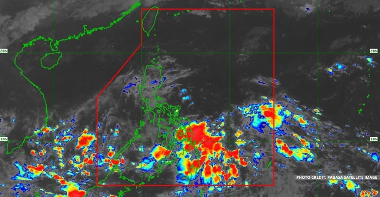
WEATHER UPDATE — According to the Philippine Atmospheric, Geophysical, and Astronomical Services Administration (Pagasa), the ITCZ (Intertropical Convergence Zone) is affecting a large portion of Mindanao, Visayas, and a large portion of the Southern Luzon area. Meanwhile, the LPA embedded within the ITCZ is affecting Palawan, Visayas, and Mindanao.
The LPA being monitored by Pagasa is now located 245 km East of General Santos City (5.8°N, 127.3°E). It is embedded along the ITCZ.
“Kahapon ng gabi ay muling pumasok ng ating Philippine Area of Responsibility itong Low-Pressure Area na ating minomonitor sa southern portion ng Mindanao area,” said PAGASA Weather Forecaster Aldczar D. Aurelio.
(We are currently monitoring the Low-Pressure Area, which re-entered our Philippine Area of Responsibility yesterday evening along the southern portion of Mindanao.)
The ITCZ is a result of the collision of winds between the northern and southern hemispheres and brings rain to affected landmasses. Due to this weather system, a large portion of the country will experience cloudy skies with scattered rainshowers and thunderstorms.
The cloud clusters in the ITCZ have a possibility of growing into an LPA as there are often formations of LPAs in the ITCZ due to the collision of winds.
WEATHER TODAY – November 18, 2022
For today’s weather forecast, MIMAROPA, Bicol Region, Quezon, and the southern portion of Aurora will experience partly cloudy to cloudy skies with isolated light rains due to the ITCZ.
Eastern Visayas, Mindanao, Zamboanga Peninsula, and Caraga Region will experience cloudy skies with scattered rainshowers and thunderstorms due to the LPA and ITCZ.
Meanwhile, Metro Manila and the rest of the country will experience partly cloudy to cloudy skies with isolated rainshowers or thunderstorms due to Localized Thunderstorms.
Watch the 5 AM weather update today below:
– WhatALife!
Source: (PAGASA)
Also read: PAGASA: ITCZ and LPA affecting Mindanao, Shear Line affecting Luzon

Leave a Reply