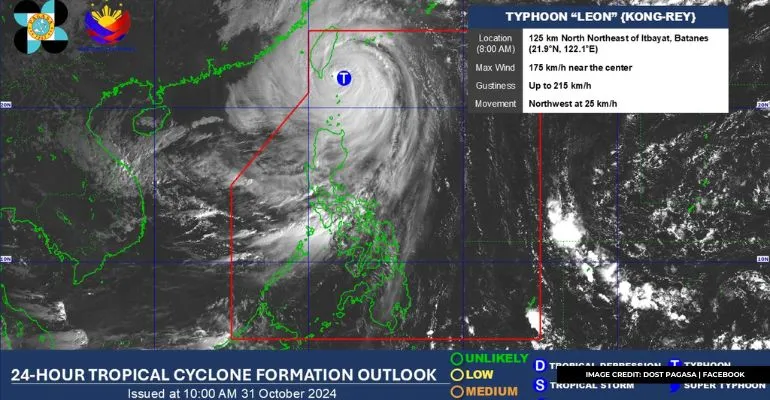
According to the Philippine Atmospheric, Geophysical, and Astronomical Services Administration (PAGASA), the current Super Typhoon Leon update has intensified.
Super Typhoon Leon, internationally known as Kong Rey, has declared Itbayat and Basco in Batanes under Tropical Cyclone Wind Signal (TCWS) No. 5.
As per PAGASA’s 5 AM bulletin on Thursday, October 31, the super typhoon’s eye was located around 100 kilometers (km) east-northeast of Itbayat, Batanes. It was packing winds of 195 kilometers per hour (kph) and gusts reaching up to 240 kph.
Also Read: Bagyong Leon Intensifies Into a Super Typhoon
Furthermore, Super Typhoon Leon’s winds extend up to 600 km from its center, with its force hitting Batanes’s eastern and northern parts. Strong to gale-force winds are also affecting nearby areas.
The rest of the province is under Signal No. 4, with gusts ranging from 118 to 184 kph.
Moreover, Super Typhoon Leon has declared the northern portion of Babuyan Island under Signal No. 3. Meanwhile, below are the areas currently under Signal No. 2:
- Rest of the Babuyan Islands
- Mainland Cagayan
- The northern portion of Isabela
- Apayao
- Ilocos Norte
Also Read: Bagyong Leon Enters the Philippine Area of Responsibility
Here are the areas under Signal No.1:
- Rest of Isabela
- Quirino
- Northern and central portions of Nueva Vizcaya
- Abra
- Kalinga
- Mountain Province
- Ifugao
- Benguet
- Ilocos Sur
- La Union
- Northern and central parts of Aurora
In addition, PAGASA has also highlighted the possibility of life-threatening storms that could reach over three meters along the coastal areas of Batanes and Babuyan Islands. Residents in low-lying areas are advised to seek higher grounds.
Heavy rainfall advisories with potential flash floods and landslides are also in place in the Cordillera Administrative Region, Quirino, and other mountainous areas.
Stay tuned for more weather updates on Super Typhoon Leon.
Keep Reading: Typhoon Kristine Delays October 2024 CPALE

Leave a Reply