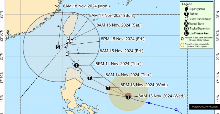
As of 11 p.m. on Tuesday, November 12, Severe Tropical Storm Ofel (Usagi) intensified significantly over the Philippine Sea. It prompts the Philippine Atmospheric, Geophysical, and Astronomical Services Administration (PAGASA) to raise Signal No. 1 in several parts of Northern Luzon.
The storm’s maximum sustained winds have increased from 95 kilometers per hour to 110 km/h. It has a gustiness reaching up to 135 km/h.
PAGASA forecasts that Ofel may develop into a typhoon on Wednesday, November 13. In fact, it potentially brings stronger winds and heavy rainfall to affected regions.
The typhoon Ofel update was last recorded 630 kilometers east of Virac, Catanduanes, moving west-northwest at a slightly slower speed of 25 km/h. Signal No. 1 is currently in effect in Cagayan. Some included areas are the Babuyan Islands, the northeastern part of Isabela, and eastern Apayao. These areas have 36 hours to prepare for Ofel’s impact.
Also Read: Tropical Depression Intensifies Into Tropical Storm Marce
On Wednesday, November 13, Ofel is expected to bring intense rainfall to Northern Luzon. Cagayan and Isabela are likely to experience over 200 millimetres of rain. With this, it led to a heightened risk of floods and landslides.
Areas such as Apayao, Abra, and Batanes are also forecast to receive heavy rainfall. While moderate rain is expected in Aurora, Benguet, and Ilocos provinces.
Additionally, strong to gale-force winds are anticipated for Camarines Norte, Catanduanes, and parts of Quezon and Isabela. PAGASA has warned small vessels to avoid rough seas in affected areas, where waves could reach up to three meters high.
If Ofel continues on its predicted path, it may land in Cagayan or Isabela by Thursday, November 14, before possibly moving over the Luzon Strait on Friday.
Check the information below to learn more about the latest Bagyong Ofel update and the importance of monitoring its movement in the Philippines!
Also Read: LOOK: List of Typhoon Emergency, Rescue Hotlines
What safety precautions should residents consider as Ofel approaches?
People in the Northern Luzon area should secure loose outdoor items, reinforce roofs and windows, and prepare emergency kits with essential supplies like food, water, and medicines. Those living near rivers, coasts, or landslide-prone areas should be vigilant about evacuation alerts and avoid risky areas like low-lying roads.
For small vessel operators, it’s important to avoid going to sea, as rough waves are expected. Preparing early can help reduce the storm’s impact on safety and property, particularly since heavy rains and floods are forecasted for areas like Cagayan and Isabela.
Why its important to monitor the movement and intensity of Ofel
PAGASA has noted that Ofel could intensify into a typhoon, bringing even stronger winds and more rainfall. Knowing Ofel’s location and potential track allows for more precise warnings, reducing risks of injury and property damage.
Additionally, monitoring can help anticipate which areas are most likely to be affected by floods and landslides. In this way, it allows timely implementation of preventive measures.
Currently, PAGASA monitors Tropical Storm Man-yi, which could enter the Philippine Area of Responsibility in the coming days.
Keep Reading: How to File for Typhoon Carina Calamity Loan in the Philippines (SSS, GSIS, Pag-IBIG)

Leave a Reply