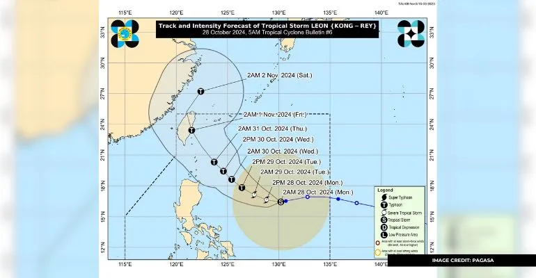
According to the State Weather Bureau, tropical typhoon Kong-Rey, known locally as Bagyong Leon, entered the Philippines on Saturday night, October 26.
The Philippine Atmospheric, Geophysical, and Astronomical Services Administration (PAGA-ASA) said it entered the Philippine Area of Responsibility (PAR) at 7:30 PM this weekend.
It’s reported that the storm’s center was estimated at 1,355 kilometers east of Central Luzon. An update at 5 AM on Monday reported that the bagyo was 40 kilometers east of Central Luzon.
It’s now moving westward at 10 kilometers per hour (kph), with winds of 85 kph near its center and gustiness of around 105 kph.
Also Read: Philippine Areas Under Signal No. 1 Due to Bagyong Kristine
Tropical Cyclone Wind Signal No.1 is still declared in the following areas in Luzon:
- Eastern portion of mainland Cagayan (Santa Ana, Lal-Lo, Gattaran, Baggao, Santa Teresita, Gonzaga, Peñablanca)
- Eastern portion of Isabela (Maconacon, Divilacan, Ilagan City, San Pablo, Cabagan, Tumauini, Palanan, San Mariano, Dinapigue)
- The northeastern portion of Catanduanes (Pandan, Bagamanoc, Panganiban, Viga)
According to PAGASA, netizens in these areas may expect 39 to 61 kph winds and irregular rains within the next 36 hours.
Furthermore, the State Weather Bureau forecasts that Bagyong Leon will closely pass over Batanes by Wednesday or Thursday.
Also Read: Government Prepares for Bagyong Kristine’s Arrival
“Sa araw ng Biyernes, maaaring mag-landfall ang gitna o center ng bagyong Leon sa Taiwan,” state weather specialist Aldczar Aurelio added.
He also mentioned that Typhoon Leon may intensify as it passes through the sea.
“Maaaring ngayong hapon ay lalakas ito at magiging severe tropical storm category,” he added.
Look out for more updates on Bagyong Leon as it progresses over the country.
Keep Reading: Pinoy Personalities Assist Victims of Bagyong Kristine

Leave a Reply